Cahokia was a city.
Not a village. Not a settlement. A city — with a population estimated at 20,000 people at its peak around 1100 CE, making it larger than London at the exact same moment in history. It sat at the confluence of the Mississippi, Missouri, and Illinois Rivers — the most strategically valuable location on the North American continent. It had neighborhoods, marketplaces, a wooden palisade wall four miles long, and at its center, a platform mound covering fourteen acres of ground and rising one hundred feet into the sky.
Today it is a state historic site in Illinois. You can visit on weekdays between 9am and 5pm.
Admission is free.
One thousand miles east, in Lincolnshire, England, there is a place called Yarborough Camp. It is an Iron Age earthwork — a raised mound of earth and timber used as a fortified stronghold. The Old English name for this structure is eorth-burg: earthwork fortress. The families who lived near these structures carried the name forward as a surname. Yarborough. Yarbrough. The name means: I live at the mound.
Two mounds. Two continents. Built within centuries of each other. Serving identical functions — military command, political authority, spiritual power, territorial claim.
One is in the archaeology textbooks as evidence of European civilization. One is in the archaeology textbooks as evidence of a "pre-literate culture."
Crowns & Codes is asking why.
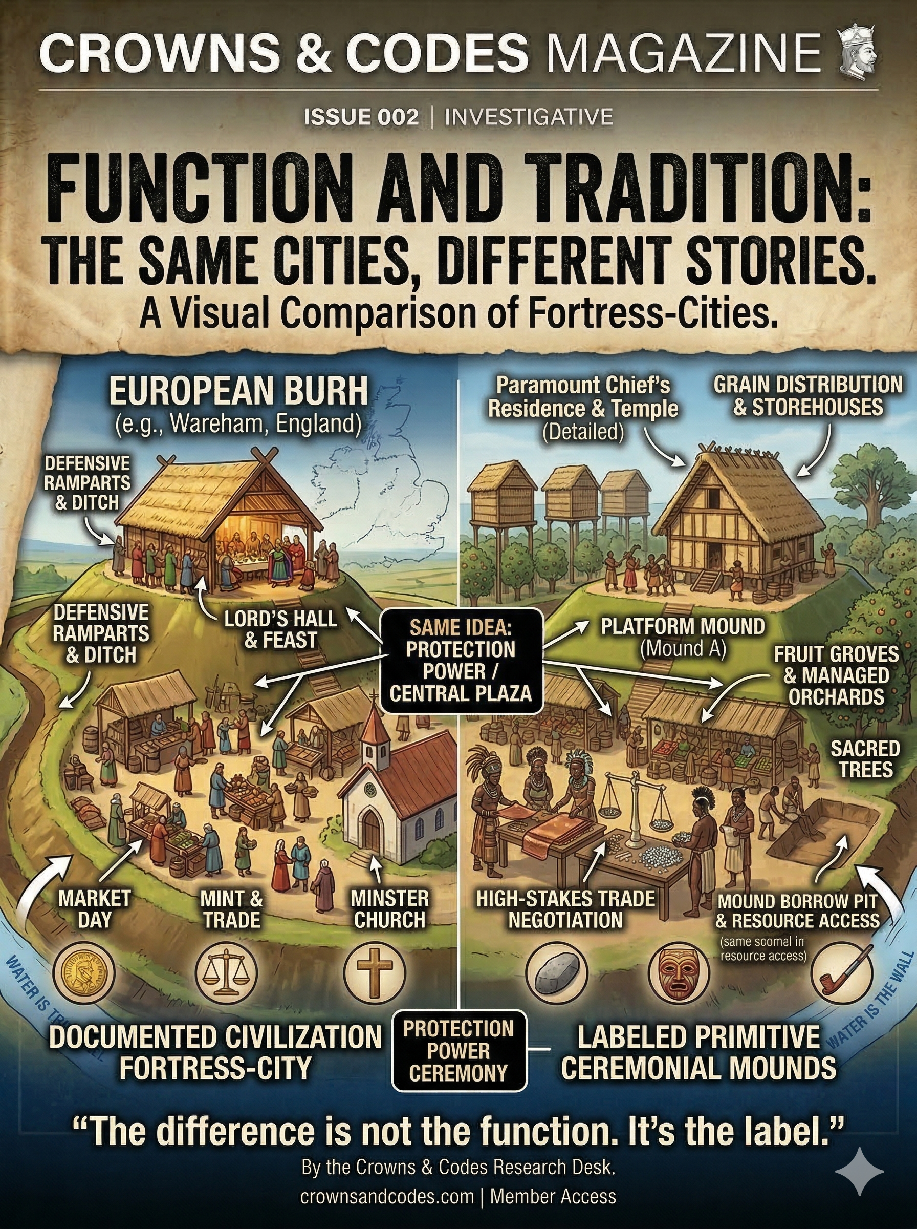
Part One: The Burh — Europe's Mound Technology
The burh — spelled variously as burg, borough, burgh — is one of the oldest words in the Germanic language family. Its root meaning is simple: a fortified, elevated place. A mound with a wall. A hill with a purpose.
Under Alfred the Great of England in the late 800s CE, the burh became a formal military and administrative network. Alfred ordered the construction of a system of fortified towns across England — each one a raised earthwork with a defensive palisade, spaced close enough that no point in the kingdom was more than twenty miles from a burh. The burh was not just a fortress. It was a tax collection point, a market center, a census location, and a seat of legal authority.
The logic was explicit: control the high ground, control the record, control the land.
After the Norman Conquest in 1066, William the Conqueror imported a refined version of the burh called the motte-and-bailey. The motte was a man-made earthen mound — sometimes built from scratch, sometimes constructed over an existing natural hill. On top of the motte sat a wooden tower. The man on top of the mound owned everything he could see.
Between 1066 and 1200, the Normans built over 700 motte-and-bailey castles across England and Wales. Each one was a physical claim to territory. The surnames that came from these structures — Yarborough, Burrows, Burton, Borough — are carried by millions of people today who have no idea their name is a deed.
Part Two: The Mississippian Mound — America's Mound Technology
Between 800 and 1600 CE — the exact same centuries the Norman motte network was being built across Europe — the Mississippian culture was constructing the most sophisticated earthwork civilization in the Western Hemisphere.
The Mississippian mounds were platform mounds: truncated pyramids of packed earth, sometimes faced with clay, built in deliberate stages over generations. They were not burial mounds. They were not accidental. They were engineered structures built to precise specifications for a specific purpose.
The purpose was identical to the European burh.
Political authority: The chief's residence and the temple sat on top of the mound, physically elevated above the population. The man on top of the mound owned everything he could see.
Military command: Platform mounds provided unobstructed sight lines across the river valley floodplains. An attack visible from the mound gave the garrison time to respond.
Administrative center: The plaza surrounding the central mound was where markets, ceremonies, and political assemblies happened. Every significant transaction in the Mississippian world happened in the shadow of the mound.
Territorial claim: The mound announced to every approaching party — friendly or hostile — that this land had an owner, a government, and a military capacity.
| Feature | European Burh / Motte | Mississippian Platform Mound |
|---|---|---|
| Period | 800–1200 CE | 800–1600 CE |
| Construction | Man-made earthen mound, timber palisade | Packed earth platform, clay-faced stages |
| Function | Military command, tax collection, legal authority | Military command, tribute redistribution, ceremony |
| Who lived on top | The lord / ruling authority | The chief / Priest-King |
| Count | 700+ motte-and-bailey castles in England/Wales | 100,000+ documented mounds across Eastern U.S. |
| Largest example | Windsor Castle motte — 50 feet high | Monks Mound, Cahokia — 100 feet high, 14 acres |
The numbers are not small. Archaeologists have documented over 100,000 earthwork mounds across the Eastern United States. Cahokia alone had 120 mounds within its six-square-mile city limits. Moundville in Alabama had 29 major platform mounds covering 185 acres. Etowah in Georgia had six major mounds including one that rose 63 feet — the height of a six-story building.
These are not the works of a scattered, primitive population. These are the capital cities of sovereign nations.
Part Three: The Deliberate Erasure
In 1787, the United States Congress passed the Northwest Ordinance, which organized the territory north of the Ohio River — the heart of the mound-building region — for settlement. The ordinance described the land as "wilderness."
The mounds were already there. Cahokia's mounds were already there. The Newark Earthworks were already there.
The legal designation of "wilderness" was not a geographic description. It was a property decision. Wilderness has no owners. Wilderness can be claimed. Wilderness does not require a treaty or a purchase or a legal transfer — it only requires a survey and a settler.
But the mounds presented a problem. They were obviously constructed. They were obviously the product of organized, sustained human effort. They were, by any reasonable standard, evidence that the land had owners — had always had owners — and that those owners had built a civilization on it.
The solution was the "Mound Builder Myth." Beginning in the late 18th century and running through most of the 19th, American scholars, politicians, and popular writers promoted a theory that the mounds had been built not by the Indigenous people of the region but by a vanished "lost race" — variously described as Phoenicians, Vikings, Israelites, Welshmen, or a mysterious pre-Indian civilization that had been wiped out.
The theory was false. It was known to be false by many of the scholars promoting it. The Indigenous people standing next to the mounds consistently said their ancestors had built them. Their oral histories described the construction, the purpose, the astronomical function, the ceremonial significance.
Those accounts were dismissed as legend.
The Mound Builder Myth served one purpose: if the mounds were built by a lost race, then the current Indigenous population were not the heirs of the civilization that built them. They were squatters on someone else's ruins. And squatters have no deed.
The myth kept the land legally available for settlement for over a century — until the Smithsonian Institution's Bureau of Ethnology formally debunked it in 1894 after excavating hundreds of mounds and finding continuous cultural evidence connecting the mound builders directly to the living Indigenous populations of the region.
By 1894, the land was already gone.